Canalaz/Kanalac - Mount San Martino
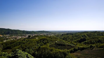
Mount San Martino (895 meters above sea level) is located between the initial, almost parallel sectors of the Alberone and Cosizza streams. The slopes are steep and are crossed by several valleys along which smaller streams flow, feeding into the larger torrents. The vegetation consists of thermophilic and mesophilic deciduous forests. The southern and western slopes are rich in mixed woodlands with aspen, willow, chestnut, major ash, sycamore, maple and hazel, which originated following the abandonment of once prevalent mowing meadows. The dominance of black hornbeam on the outcrops of organogenic carboniferous rocks contrasts with mixed ash groves, with beech, sycamore, and wild lime, which grow in soils lying on marl, sandstone, and marly limestone. To the right of the ridge descending to Topolò pass, there are oak forests with white hornbeam, while in the northern sectors there are sub-mountain beech forests. There are few meadows still mowed near the towns on the southern side: Canalaz, Plataz, Brida, and Seuza. The summit area, with its small church of the same name, is a prime panoramic viewpoint, offering views over the Colovrat ridge and the villages of Drenchia and Clabuzzaro.
Accessibility: From the road, before Canalaz, a forest track branches off and climbs the western slope, ending in a large mowed meadow. From here, the path first reaches the church and then the summit.

The Village, ph. Giorgio Bianchi, Archive MCC

The Village, ph. Giorgio Bianchi, Archivio MCC

ph. Giorgio Bianchi, Archive MCC

ph. Giorgio Bianchi, Archive MCC